Moderate

Trail
Length
2.59 miles round-trip
A nice breeze will be at your back most days. This trail connects to the top of the eastern ridge. Near the top are some easily avoidable ruts. You'll get ocean and beach views if you turn around and look back. It never gets too steep. Near the upper end,...

Trail
Length
3.62 miles round-trip
The TCC Trail is named for the Tamalpais Conservation Club, a group that has been maintaining and preserving the area's trails continuously for the last 100+ years. The TCC Trail (like many others in the area) was built by the Civilian Conservation Corps as part of the New Deal program...

Trail
Length
5.99 miles round-trip
The Spine Trail is a great way to experience the remoteness and wild beauty of Rancho Corral de Tierra . Park along Etheldore Street, then hoof it down Ranch Road toward the Ember Ridge Equestrian Center (don't disturb the horses...or the staff, please!). Find the signs for the Spine Trail,...

Trail
Length
2.22 miles round-trip
Driving up to the parking area is steep, and it's a premonition of what the trail will be like. You guessed it, the ascent will be too. However, switchbacks make the climb much easier. Near the top of the ridge, it flattens out and becomes a fire road. Be sure...

Trail
Length
2.58 miles round-trip
The trail loop begins on the single-track Oakwood Valley Trail and finishes on the broad Fire Road Trail.

Trail
Length
0.11 miles round-trip
Access to the beach is via a paved drive or stairway down from the parking lot to water level.

Trail
Length
1.20 miles round-trip
Surrounded by urban development in Pacifica, Milagra Ridge forms what biologists call an island ecosystem. Despite this isolation, this 250-acre park hosts a surprising diversity of natural resources. It is home to threatened and endangered species like the mission blue and San Bruno elfin butterflies.
Trail
Length
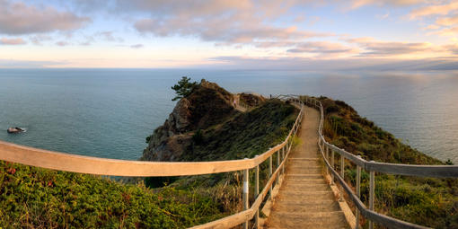
0.02 miles round-trip
This trail to the Muir Beach Overlook offers breathtaking views of the Pacific Ocean and Marin County coastline.

Trail
Length
2.96 miles round-trip
During the Cold War, anti-aircraft missile stations were constructed on the northern and southern sides of Rodeo Lagoon in the Marin Headlands . Radar sites were placed atop Hawk Hill and Hill 88. When the military decommissioned these stations, they left the remnants of the buildings and structures in place...

Trail
Length
0.82 miles round-trip
This segment of the Bay Trail, skirting the northern edge of Fort Mason , features lovely Golden Gate Bridge vistas and an overhead view of the piers and buildings of lower Fort Mason, the port of embarkation from which 1.6 million military personnel shipped out to the Pacific Theater.